 We will be updating this City Charter Review blog as the process moves forward.
CCC’s Steering Committee has discussed and voted on key Charter Review Issues. A majority of us support the following: (see Rationales Below)
Key discussion point at the March 28 meeting: a working consensus on the question: Should the head of the executive branch be an elected official (strong mayor) or remain an appointed position by the city council (city manager)? (See Above Chart ).
TIMELINE AND PROCESS
RATIONALES BEHIND CCC DECISION
0 Comments
CCC Looks back at 2022 and forward to 2023 SIX Best Cambridge outcomes in 2022
SEVEN Unfortunate Cambridge outcomes in 2022
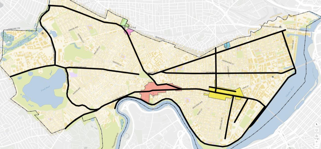
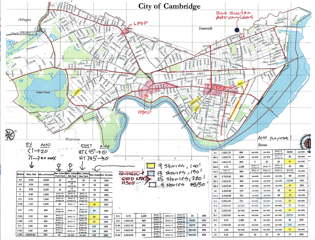
THANK YOU for all your help and Support this year! NEW AHO CITYWIDE UP-ZONING PETITION with potential impacts on every city property is submitted by Councillors Azeem, McGovern, Simmons, and Zondervan (11.21.22) and is likely on a fast track toward approval. 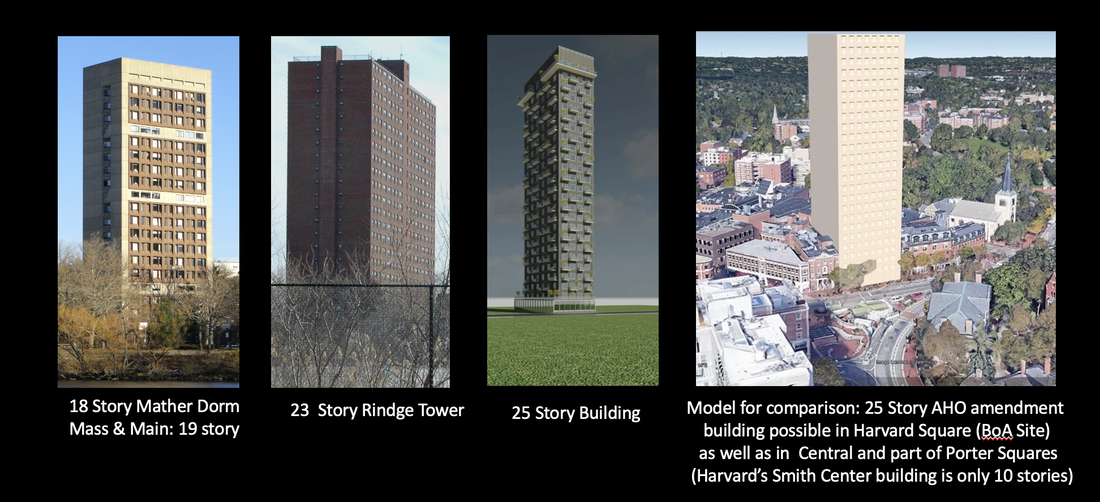 To be allowed if the AHO UP-ZONING PETITION PASSES: Affordable Housing Developments in major Cambridge and Minor Corridors (see map below) can become 10, 11 or 15 stories high. In Cambridge City Squares (see map below) AHO structures can be taller than the current 23 story Rindge Towers. These structures also will be allowed anywhere in the city if multiple properties are joined together. Above right is an image of what such a 25 story structure might look like in Harvard Square at the Bank of America site. By way of comparison, the very tall Harvard Smith Center is only ten (10) stories tall. We are currently working with architects to create models of likely impacts for other neighborhoods of the city. What parts of the city will be impacted by this zoning petition, and to what degree? Those residents living near major Squares (or several-property compositions) may see new structures reaching 25 story (280') heights. Those residents living near avenues or corridors in the cities may going forward have affordable housing developments reaching 9, 10 or 13 stories without setbacks, parking, or green spaces. SEE MAP BELOW. Read the petition language at the PURPLE button below: Sign the Petition to Stop the Massive Upzoning BELOW This new city-side radical up zoning petition is on a fast track to confirmation. It will be discussed first at the November 21 City Council Meeting, and from there will either be likely moved to the Ordinance Committee or the Housing and/or Neighborhood Committee, and afterwards to the Planning Committee and then back to City Council for a final vote. This will take place over the Thanksgiving week through the December Holiday Season with a possibly final vote in January. Of note: last year six AHO developments were approved (with some 1000 units) so the current system is working. Moreover the city itself owns land with 13 parking lots in Central Square, and building additional AHOs on city-owned land makes for more financial sense and will not increase property values/housing costs to the same degree. Robert Winters of Cambridge Civic Journal writes of this radical up-zoning petition: "This may well be the most outrageous proposal I have ever seen from this or any other Cambridge City Council." Any such structure built will become the new norm against which new structures of any time will be compared for local "context" and architectural appropriateness in arguing for extra historical or zoning allowances. KEY TAKE AWAYS
MAJOR ISSUES are in play in this radical new AHO zoning petition.
  Timeline on the new AHO Amendment: This will first be discussed at the Nov. 21, 2022 City Council Meeting and likely will be forwarded to the Housing and/or Neighborhood and Long-Term Planning Committees for discussion and public comment. After this it would likely come back to the Ordinance Committee before going to the Planning Board and then back to City Council for ordination, likely in the early New Year.
Spending Taxpayer Money like Water - As Housing Costs and Property Taxes Rise to New Heights10/30/2022 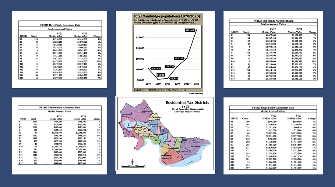 We are a city of very smart residents, many working in positions that require active professional engagement (see chart below). Alas, too few of us are paying close attention to how the city is spending our tax dollars, and how quickly our taxes are growing despite the fact that we have more and more city residents and commercial developments to help pay the bills. The above charts, graph and map provide insight on this (Y23 - see link below), as does therecent city property tax letter. We as a city are spending this property tax money like water and our residential property tax burden has gone through the roof making housing costs more expensive for nearly everyone. THE CITY IS SPENDING $$ AT AN ALARMING RATE and there is less and less transparency
Many of us just received our FY23 Property Tax Update and the news is not good, particularly when increased property tax percentages are addressed, much less averaged out over the last five years. In the case of one three family home owner living on a fixed income (in Cambridgeport), her taxes went up 9.7% - way above inflation. A three decker in Mid-Cambridge went up 23.7% over 5 years or 25.9% since 2018. In the case of two single family home owners (one in West Cambridge and one in East Cambridge, the five year percentage increases on their property taxes were 26.8% percent increase and 38% increase over the same 5 year period respectively. The multiplier effect is not being considered in all of this. Yes, the City council voted on October 3, 2022 to decrease taxes by 1% on residential properties ($0.06) and commercial properties ($0.85) but that is nothing comparable to the huge tax increases we continue to see. The anticipated budget increase of 6.5% for &23 is massive - and is not only impacting housing costs negatively (higher and higher property taxes that increase rents) but also is likely one of the reasons we are seeing fewer and fewer of our local businesses able to survive. And, what is happening with our money? The City (with City Council approval and encouragement) is spending as if there is no tomorrow. Money to them is like water and it is driving up housing costs to an untenable degree.
OF FURTHER NOTE: Most of us are suffering through the noise and inconvenience of new commercial and residential building work or renovations all year round. One would think that this might come back to us in lower city taxes. Just the opposite. And, the notion that an enormous increase in the value of our homes is a benefit to the vast majority of our residents is specious at best. This is worse than "paper wealth," because our taxes rise as a result, and because the one way we can access that money is to sell one's home (or mortgage it, but then one has to pay it back). Everyone still has to live somewhere, and one cannot live in a safe deposit box. Unless we uproot ourselves and move somewhere else entirely, leaving all the benefits of Cambridge behind, we probably can't afford a new place that is as livable as the places we are living already. We are tired of people blindly repeating such foolishness as property value increases being a plus. Such people don't stop to think about what they're saying. The major monetary value of one's home to those who are living there is that one is not at the mercy of ridiculously increasing property values to the same extent as someone who rents, and home owners here should be very grateful for that. It's the only reason many of us can still afford to live here. If we had our druthers, property values would have increased far less so that more of of our friends and neighbors could afford to stay here. That would be real value, something people who see everything in monetary terms don't seem capable of understanding. Those of us who live on fixed incomes, have salaries that have not kept up anywhere close to inflation and/or are just making ends meet before all these housing cost rises are suffering significantly. Cambridge, we noted above, has many very smart residents, working in professions that call for regular assessment of data and close analysis of key results (professors, scientists, managers, others - see chart below). We should be expecting the same professionalism, care, insight and oversight on the part of our city Councillors and city leaders. The kind of rampant spending we are seeing today, our untenable housing cost increases (based on a tax structure dependent on ongoing property value increases), and so few tenable socially important results is making city decision-making increasingly untenable. Please urge the new City Manager and our Councillors to look at the larger picture and put our fiscal house in order. It is time to take a deep dive into how the city collects and spends our money. The long time policy of massive commercial development in order to keep residental rates low is NOT working anymore. New commercial development is driving up values so far that even our low rates leave our property owners (including landlords) with huge bills. The balance is out of whack. What the city needs to do is to actually plan as opposed to throwing money at problems as they crop up. Link to City Y-23 tax rate newsletter: https://www.cambridgema.gov/-/media/Files/financedepartment/propertytaxnewsletters/FY23/fy23taxratelettertocitycouncil.pdf 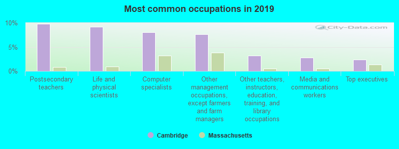 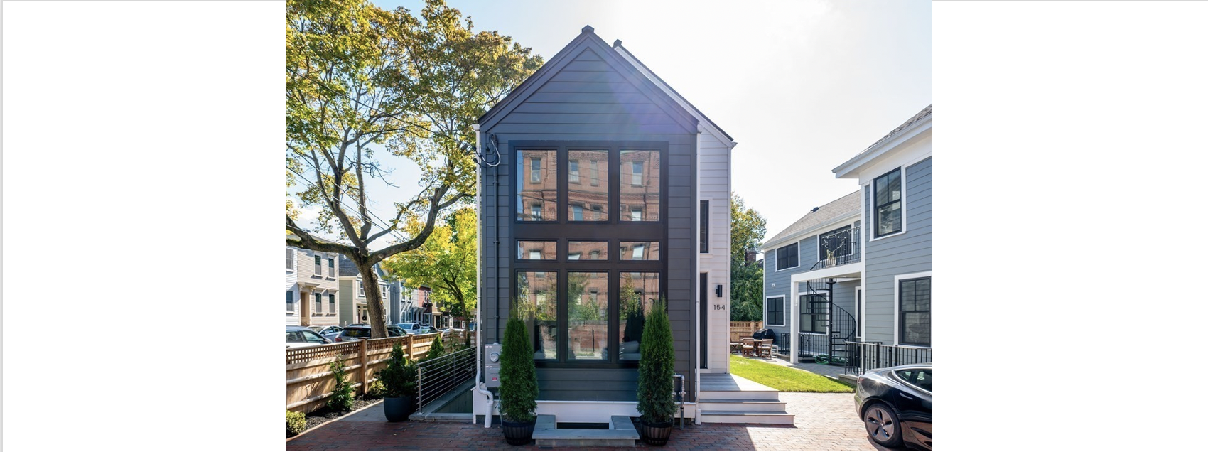 top image: 154 Thorndike Street (the first beneficiary of the new City Council vote to end Parking Minimums. BLOG UPDATE (July 30, 2023) On July 29, 2023, a Cambridge resident, who not only sits on the Board of the pro-developer pac, A Better Cambridge (ABC), but also has served on the Election Campaign Manager of ABC candidate Burhan Azeem published an opinion piece on Cambridge Day extolling the benefits of ending Parking Minimums in the City of Cambridge HERE The author chose NOT to identify herself in any of these roles. The ostensible rationale for the opinion piece is an 18-unit East Cambridge condominium complex with four affordable units. While new housing is good, most likely this also would have been approved by the BZA, had the once-necessary special permit been sought. The author points to the related question of parking, noting that the residents: "...can pay for a reserved parking space in a nearby garage or use publicly subsidized free parking (also known as on-street parking). Some may chose to use a combination of public transport, biking and occasional car-sharing options instead of owning a car." There is also The Lechmere T stop, she adds. All this is true, but her piece misses (leaves out) the broader implications of this unfortunate bill. Not only does it (as here) lead to important class and financial differences in available city housing (which residents will have on site parking or the financial means to pay for it. The piece also leaves out the huge environmental impacts of this bill, names that it allows for the removal of critical green spaces and trees in favor of denser housing, worsens our severe problems with environmental justice (and heat island impacts in our denser neighborhoods, and runs counter to the Envision Report recommendations to increase green spaces and trees in our most dense neighborhoods. In addition as a result of this bill, even more residents will be circling the denser neighborhoods looking for places to park so they can get to work or to the doctor's office - adding to the negative environmental impacts. 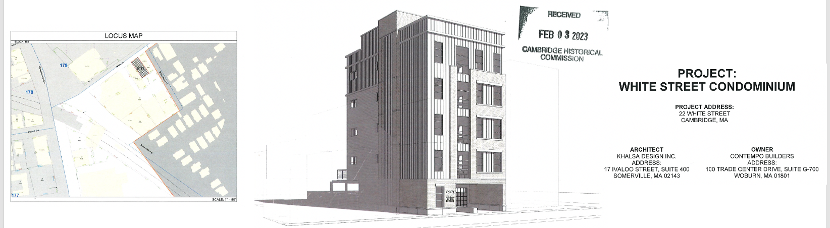 A different recent example of why this decision to end parking minimums has been harmful in the city can be seen in the recently presented 22 White Street condominium complex (see below drawing ) that came before the Cambridge Historical Commission in February 2023. This is a market rate multi-story development directly adjacent to the Porter Square parking lot (with plenty of available parking AND a T stop a few hundred feet away). What happened in this case? The developer insisted on adding parking within the building itself, taking away critically needed units (none of which would be affordable because the basic unit number requirements were not met). In this case, as in the first example explored below (that occurred the night the parking minimum bill was approved), market rate developers generally chose to add parking on their property (even if not required) because they can make far more money from the sales of units with on site parking. What these examples make clear is that this policy promotes an even greater divide between "haves" and "have nots" - those in affordable housing for the most part will NOT be able to park the cars they need to get to work easily and will continue to struggle to find increasingly rare on-street parking in the neighborhood, generally after circling the blocks numerous times. Or, they will have to pay steep fees for parking in private garages. The City Council move to end parking minimums was OPPOSED by the Cambridge Housing Authority because it would make harder for Affordable Housing developers to compete with market rate property developers in acquiring these properties. Specifically they state "The Cambridge Housing Authority (CHA) is writing to express its concerns regarding the proposed petition to revise the City’s Affordable Housing Overlay to make off-street parking consistent with base zoning. The proposed petition has both immediate and long-term effects and should not be adopted." Read the December 2021 CHA letter to City Council on this problematic legislation HERE Sadly, this author (consistent with her association with the builders' pac, ABC, also misinforms readers on the number of Cambridge residents on the Affordable Housing List. As even ABC councillors now admit, some 3,000-3,500 city residents are on these lists currently NOT 21,000. The latter number represents the full sweep of individuals in need around the broader are nd country who would like to live in Cambridge housing, usually signing up for multiple lists at the same time. IMPACTS: THE ENDS OF PARKING MINIMUM REQUIREMENTS (OCTOBER 2022) On Monday October 24, 2022, Cambridge City Council ended parking minimums: As CCC noted in our recent blog post, removing parking minimums in other cities like Buffalo NY has NOT meant that people create fewer parking spaces on their residential or commercial properties (indeed they often increase) but rather that the city has less control over these decisions. What this means is that the rationale that Councillor Burham Azeem and other supporting City Councillors used to justify this decision was both faulty and disingenuous. Councillor Dennis Carlone was the sole voice in opposition. Councillor Toner added an amendment to require the city to study impacts of this decision every three years, which passed, and this is fortunately now part of the city-wide ordinance. The problem for us as a city is that our policies now are driven more by ideology than on facts or real world consequences. We have many more people moving in, many more jobs and all that will happen is that lower income people and seniors and people with families who need cars to get where they are going will have a much more difficult time here – and the environment will suffer as they look for parking on the street unless they live in the wealthier neighborhoods where onsite parking is the norm As CCC has pointed out, most likely this will result in more multi-million dollar infill luxury housing will be built benefitting developers and investors at the expense of local residents, pushing up property values and taxes significantly for everyone, and impacting very negatively the environment.. There was one case at the BZA with parking minimum concerns when the City Council was voting on parking minimums. In short, we already have the first example (see image above). This case is 154 Thorndike, a nearly $1.7 million East Cambridge infill luxury home project. You can find it on Zillow. (See image at top of page). What is for sale here is a freestanding unit in a three-unit condo. The other two units are in another building that was mostly already there. The owner/developer decided to give the tandem parking spaces to one unit in the other building and a single space to this new unit. The other unit doesn't get one. Take a look at the site plan presented to the BZA, we have now allowed for one unit to get two parking spaces - completely at odds with the intent of the new order. Moreover this freestanding unit was conveyed to the lender by a deed in lieu of foreclosure from Massimino's company, and the current beneficial owner appears to be The Grossman Companies. Often this type of situation of a deed in lieu of foreclosure raises serious red flags with oversight agencies (think Trump properties kinds of issues). In addition, pretty much the whole yard is now paved over – which is terrible re our serious issues around climate change. In short this first example is not bringing down housing costs (just the reverse) In short this first example is not helping the environment (just the reverse) In short this decision by City Council it is taking away one of the few points of scrutiny in the process that might allow neighbors and others to address related impacts. Welcome to the current era of ideologically driven City Council decision making aimed at largely benefit the developers at the expense of everyone else. And when we look at how long it takes current Cambridge residents to get to work we can see the impacts of this kind of decision potentially on local residents. 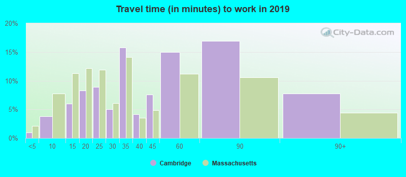 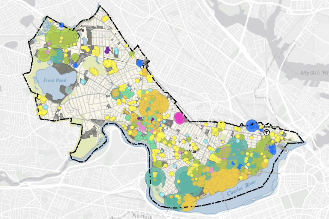 BEUDO energy performance map - 2019 data This post has been updated to reflect the current situation. What every Cambridge resident and small business owner needs to be following now! State regulations require buildings to convert from gas to electrical by 2050. See BEUDO (The Building Energy Use Disclosure Ordinance). A majority on Cambridge City Council want this conversion to happen more quickly and are pushing for a 2035 net zero date, a decade and a half earlier than Boston. While important in an ideal world, there are unintended consequences that will drive up housing costs – dramatically and other unintended consequences which is why important counter voices are being heard on this move by small businesses, commercial property owners, residential property owners, condo owners, and renters alike. .What is proposed: to require escalated retrofitting by 2035 of all a residential properties with 50 or more units as well as large commercial properties. Condo owners in Cambridge banded together to stave off this fast-clipped change because of the complex issues involved with different condo owners. CCC also successfully pushed to exclude rental properties from this early move. As one condo board member noted for a 58-unit 1909 building “each unit in my building will owe $170,352 apiece. I’d pretty much want to know what the City would do with the $10,000,000 from our building alone." These costs also would be passed on to local renters - as well as owners if they are living in their own units. During the time when these buildings are upgraded, many residents also will be required to find housing elsewhere. This is important to have in place for new buildings, but This shortened period to prepare is likely to extensively hit lower- and middle-income residents, and those on fixed income. Many will have to leave the city. Significantly, one factor being cited is that BEUDO is “not just about disclosure, mandates as taxation; Linkage as revenue generator w/o regard to incentives and unintended consequences.” Ironically the new electric sources and capabilities for this transition are not even available yet, and were we to wait until the state mandates of 2050 likely new technologies (eclipsing those available now) will make the transition far easier and far less expensive. Key questions remain, for examples whether programs like the Cambridge Community Electricity Program, for 100 percent green energy, has enough available green energy – and at what cost. Ironically too, in Cambridge BY FAR the worst offenders (the greatest energy users) are our labs who use a vast majority of this energy resources. Commercial users (especially labs) need to be addressed first and let residential units wait for the 2050 mandate. 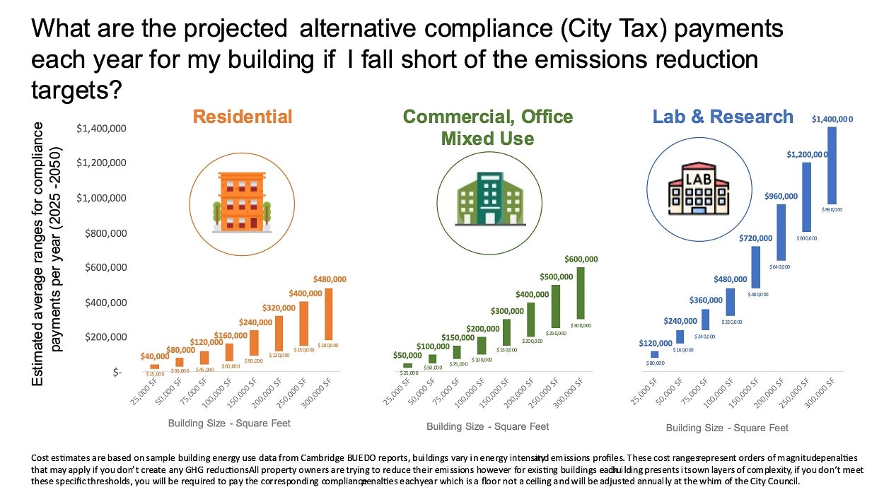 Focusing on large labs for an earlier date of compliance makes more sense considering how important current housing needs and pricing are for city residents today. Alas most Cambridge residents have not even heard of this move for existing properties. Another problem at hand, is that each building owners will have to decide on their own how to rush through this change – in some cases it means that people will loose living spaces/porches as individual units are added. Here is the list of "stakeholders" that the city chose to worked with on this: Abcam; AHA Engineers; Akelius Residential; Alexandria; Atrius Health; Avalon Bay; Biomed Realty; Boston Properties; BrightPower; BR+A; Cambridge Brands; Cambridge Housing Authority; Cambridge Innovation Center; Cambridge Redevelopment Authority; Cambridge Savings Bank; CBRE; City of Boston; Code Green Solutions; Equity Residential; Eversource; Google; Jacobs; Jones Lang Lasalle; Just a Start; Harvard COOP; Harvard University; Homeowners Rehab, Inc; Laverty Lohnes Properties; Leeder Management; Lincoln Property Company; MAPC; Marriott; MassDevelopment; MIT; MITIMCO; New Ecology; Novartis; Partners Healthcare; Upland Capital. A new effort called Electrify Cambridge has been introduced for residents. This program seeks to help Cambridge renters and homeowners with this process. One can sign up for the Electrify Cambridge Launch Webinar to learn about the program and get questions answered on your specific costs, or you can call the Cambridge Energy Helpline at 617-430-6230 and sign-up for a free consultation. But there remain a number of challenges. A July 9, 2023 Boston Globe article titled “Cambridge rule targets emissions” lays out some of these issues. According to one Cambridge opponent, Denise Jillson of the Harvard Square Business Association: Some of these BEUDO amendments “are unworkable” and “penalize business owners, property owners and residents for not being able to achieve the unachievable by imposing financial burdens that are unfair and unjust.” In addition to costs, another is whether the electricity exists to make these required transformations possible. Still another is the available work force. A July 20,2023 article in the Boston Globe “Does Mass. Have the Workers to Build a Green Economy? notes that it will take 38,100 workers to help Massachusetts transition to clean energy state according to a report by the Massachusetts Clean Energy Center (MassCEC), a quasi-public agency that supports the state’s green energy industry. The document forecasts thousands of new jobs by 2030 in order to meet the state’s decarbonization goals. And, according to the center’s analysis, Massachusetts needs its clean energy workforce to expand by 37% from the current size of 104,000 yet there remain sizable challenges to filling those positions. For example, 88 percent of companies that responded to MassCEC surveys said they have difficulty hiring workers for clean energy jobs despite the fact that “there are places where we need immediate intervention.” Moreover “Massachusetts’ clean energy workforce has grown little since 2017.” The report states that the pandemic ended up “…wiping out one in every six clean energy jobs (about 12,800). Almost half of those jobs had returned by 2022” but the states “overall labor force is shrinking…. Workers might transition from fossil fuel industries, but jobs there are estimated to fall…3 percent by 2030….Training capacity, too, is a hurdle [and]….many occupations at severe risk of facing worker shortages are also those that require extensive training, which takes time.” Another problem is the technology since “many jobs – like cost estimators and insulation workers – have changed a lot with technology, and that change is only accelerating…..Think about how rapidly technology is changing…[t]hat means these jobs are changing just as fast.” And there is the issue of diversity. Women comprise “…only 31% of this clean energy workforce, far fewer in many specialized occupations, like electricians, 98% of whom are male.” And “only 7 percent of the state’s clean energy construction workers and 11 percent of electric power line installers are Black. This is a problem for environmental justice…” The question of the city’s new gas-linkage fees are also being raised by some informed residents because the language of this particular ordinance does not comply with the city’s current zoning definitions. At present it appears that homeowners and small business building owners who add a large enough addition to comprise ½ or more their existing structure, may face very high linkage fees that apparently were not intended in the Council’s original vote. One Cambridge Councillor has urged a citywide move to geo-thermal heat pumps, but Germany has had problems with the strategy to require Heat Pumps (“Boilergeddon”) HERE Another ramification is on new design requirements. Many new buildings must now include inoperable windows (a risk in this era of COVID and electricity outages) and a call by some that windows be removed from historical preservation criteria. This change will impact renters in the city as much as property owners.  Yes, it is important that we address climate change. But let’s insist that the city focus on what really matters (policies stated in the article at the top of the letter) and labs who use much of our current energy. We could also require that new water heaters installed in the city be electric rather than gas. Let’s also be far more transparent about the proposed changes and their likely impacts on current residents.
 ENDING PARKING MINIMUMS IN CAMBRIDGE: Ending parking minimums is framed as a citywide zoning change. The final vote comes up shortly. Dennis Carlone has voted against ending parking minimums, following the lead of the entire Planning Board. Paul Toner added an amendment to the Order to add “some oversight” to the process to prevent developers from “abusing” the policy by not building sufficient parking “for a review every three years" of impacts by CDD. Patty Nolan in Cambridge Day notes for her vote that “It means that we are making it more obvious that car ownership is not something that we want to have more of in the city … The message will be that yes, it is more expensive and more trouble than in the past to own a car here….I am fully owning that and recognizing that and I think it’s the right way to go.” This seems to be the shared view of a majority of Cambridge City Councillors. Abolishing Parking Minimums is a national trend. The stated aim in the Cambridge situation is to to cut down on car usage and to enable the creation of more market rate housing (infill and other); however it will also make it easier and far less expensive for labs and commercial developers and will likely take away some current controls the city has to oversee employee transportation. A recent peer reviewed study of Buffalo NY’s decision to end parking minimums points out that the results of their decision have been very mixed. You can read it HERE: We learn from the Buffalo experience that
Unfortunately, the Buffalo report left out both new single-family and two-family homes there and properties under 5,000 square feet so we have no real comparative data. In Cambridge new single- and two-family homes (market rate infill structures primarily, or current residential demolitions) will still probably include parking because of the huge demand for this and the sizable profit for residences with parking. This is what new owners of multi-million-dollar homes expect. Another study, this one from Portland Oregon also addresses impacts of parking minimum changes. Here we learn that: "In general, the survey of residents does not show a relationship between the availability of on-site parking and car ownership among residents…. Residents at buildings with on-site parking and those without had similar levels of vehicle ownership." In short, if the aim of this new city-wide zoning ordinance is to lower the number of vehicles on Cambridge streets, this decision is not likely to help – and may make things worse. While there is downwards trend in car ownership nationally, since we are increasing the number of residential units and commercial workers so significantly, we are unlikely to see real vehicle ownership diminishing. What is surprising moreover is that the City also seems to have no idea how many cars there will be per 100 new units on the city streets. This citywide zoning change may well mean that we have more vehicles on Cambridge streets not fewer ones. One additional concern is if the Ordinance will allow people to plug in (and rent out) mobile homes or similar forms on their properties. We may know soon enough how local Cambridge residents and those who work here will experience impacts. It will be important that in our 3-year study all new buildings (or additions) be included in the analysis, as well as any increase or decrease in car registrations, parking registrations, or traffic congestion. See also this Boston Globe article. What Cambridge's 3 year report needs to look at specifically.
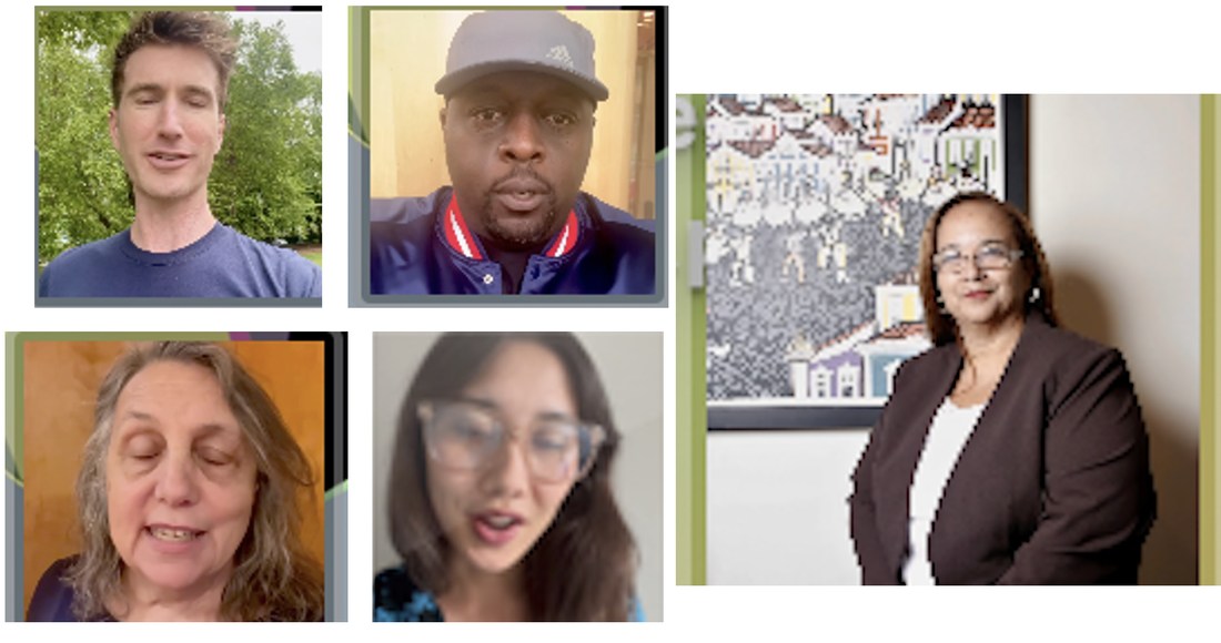
As the City Manager campaign moves towards conclusion and a final vote, a campaign video has surfaced that is being emailed to some groups around the city. This is accompanied by a social media effort to rally Councillors (and residents) around one candidate. The video itself is a "soft touch" approach and includes a number of residents, including a pastor, a weekly breakfast political discussion host, the leader of a local youth support group, and a proponent of more development who also opposes neighborhood conservation efforts. The creators of the video are not known because no information is included on who put this video together, who contacted the speakers, or who funded this effort. You can watch the short video here: It is surprising for such an important decision that no facts or data are included in this video. This information is what any such decision must be based on. And, there is an interesting back story: While the video gives no clue about who funded and filmed this effort, the accompanying social media campaign is far clearer. Based on recent social media posts, this campaign is being mounted by the city's pro-development activists and their supporters. Surprising and troubling in this effort is that one of the spokespersons on this video is well known locally for his social media attacks against Cambridge residents, City Councillors he opposes, Cambridge Historical Commission members, neighborhood group leaders and others. It is this same person who is leading the social media campaign which also is framed around attacking groups and Councillors who do not favor this candidate. It is sad to see a Cambridge city manager candidate identified on campaign materials with an individual who attacks others so readily as a matter of course. While some who appear on this video may not know about this individual's attacks, the creators of the video and those who invited and filmed the key speakers, were clearly aware of this person's problematic history and attempts to bully and silence residents who simply want a well run city. We need a city manager who will be a smart leader, who will address issues of planning, data and government transparency, and who will not be swayed by those who seek to bully others who try to make the city a better place for both present and future generations. Below are two of the posts that are part of the recent "support-campaign" for this candidate. The name calling "NIMBY" and "bigoted" framing is par for the course for the individual who posted this and his supporters, as is his opposition to those groups (like CCC and the Cambridge Residents Alliance) who want thoughtful planning rather than the current pro-development, pro-market rate (luxury) housing agenda that is fallaciously identified by this individual as "meaningful housing production." 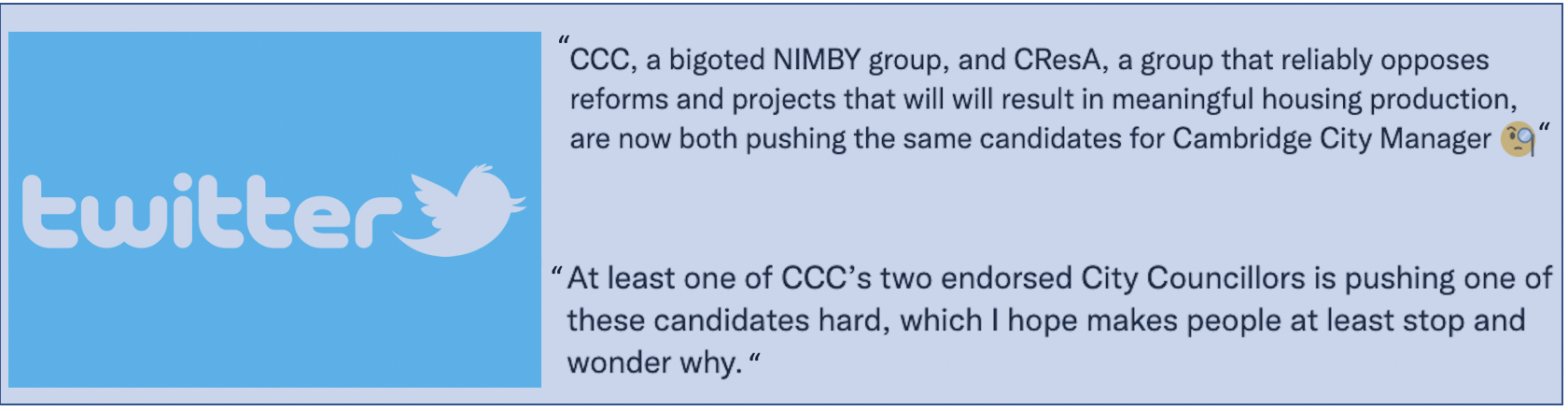 This kind of attack must stop. Candidates who promote individuals engaged in this kind of behavior in their campaign materials are continuing the problem. Cambridge can and must do better.
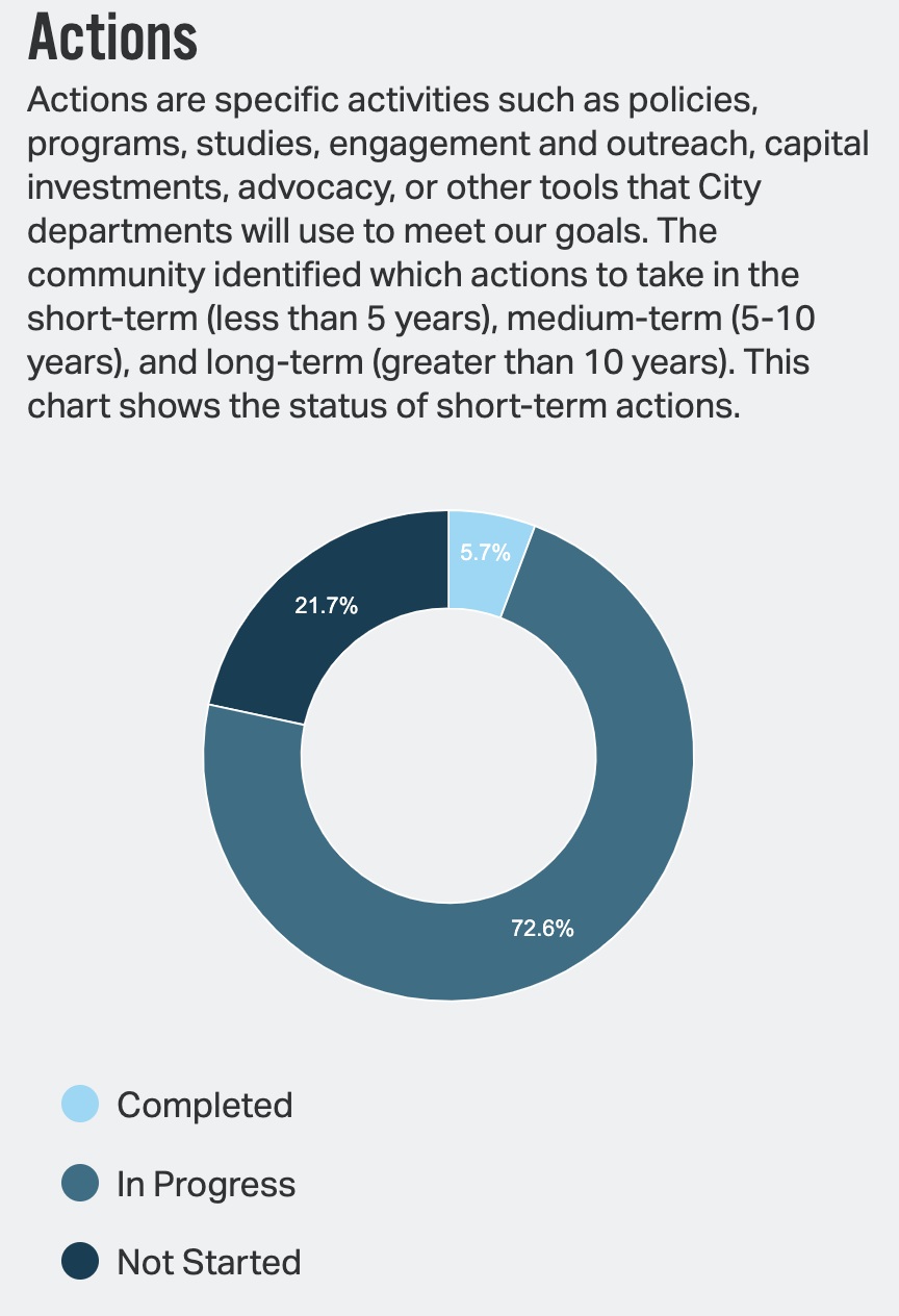
 The city’s Community Development Department (CDD) staff and others have presented us with a report on efforts to meet the Envision Goals. The city, represented with apparent satisfaction in the May 18, 2022 Cambridge Chronicle that "To date, 73% of the short-term actions are in progress." Iram Farooq, Assistant City Manager, and the Director of CDD states that "We’re pleased to share the Envision Cambridge Dashboard with the community. It shows the tremendous strides we’ve made toward realizing our collective vision for the future.” But this observation misses much of what is in play and leaves out far too much information. One of the problems with the original Envision Report is that it did not include any numbering system for the 114 or so goals that were included there. Nor in this Report did CDD add, much less link, specific goals with many of the specific goal criteria in the original report. Equally important, however, is that the Envision medium term and long-term goals, which are left out of this report altogether, are needed to show real progress by 2030 (only eight years away). You can visit their site: HERE In this report, we address each of the six categories and address them separately as they have been presented to us by CDD without addressing their specific link to the language and itemization of each goal in the original report. In addressing this report, we took up each category and offered an overall assessment of these goals - what has been achieved and what has not – as well as what has been left out of their findings. All the charts and data in this post are from the CDD report presented on the site indicated above. On why these issues matter: based on what we are seeing in the May 2022 Envision update report, it is clear that the city will meet very few of the Envision Goals by 2030 in most of the major categories.
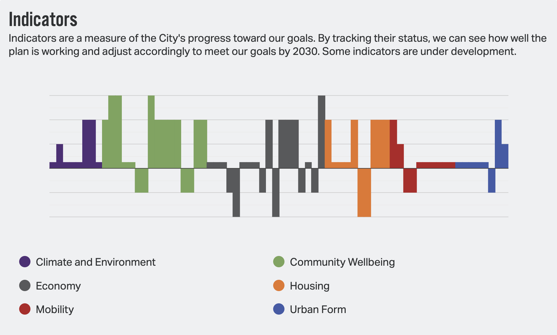 In the graph at the top of this page CDD has presented us with what they see as the successes and losses on key issues they have chosen to address in the Envision Report. They chose only certain goals to feature and address here, but even with this minimal part of the whole report, the chart clearly shows where the problems lie. In another graph (shown below in blue) provided by CDD one sees just how little has actually been accomplished to meet our 2030 goals now less than 8 years away.
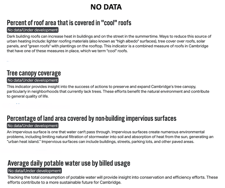
This set of indicators is deeply disturbing. The pounds of trash collected has gone down a few percentage points but not enough to show any real progress. The percentages of Cambridge lands at risk for flooding have flatlined for both 10- and 100-year storm preparation. 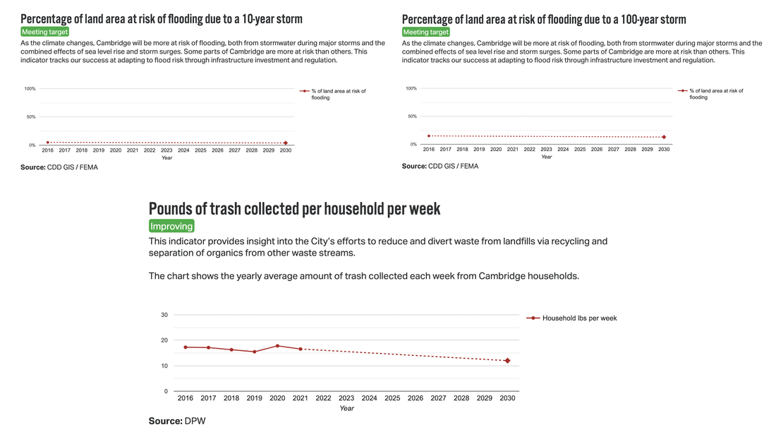 Equally troubling are the missing data in this section: tree canopy coverage; percent of roof area covered in “cool” roofs; percentage of land area covered by non-building impervious surfaces; average daily potable water use by billed usage. Part of CDD's work should be to do regular inquiries of those they have contracted for work (on tree assessments for example) to making sure that this data is available, including how many saplings have been planted and how many have died.
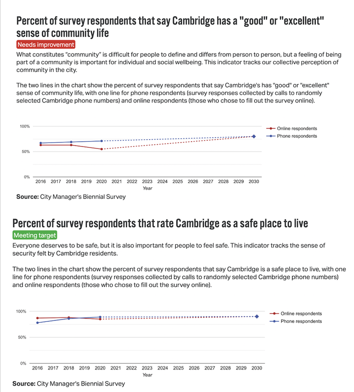
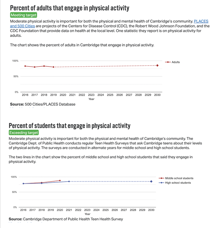
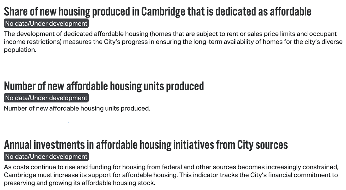
-Also troubling is how the issue of Climate and the Environment has been politicized by pro-development supporters. CDD staff has done nothing to mitigate this divisiveness, which is necessary to meet the Envision goals. ___________________________________________________________________________________________  Community Well Being receives mixed reviews. Most Cambridge residents feel very good about community life here. The percentage of survey respondents who feel safe in the city is even higher than it was. That is good news and we can thank the City Police, Social Services and others for their work. On health and wellness, a sizable number of our adults and students engage in physical activity. It will be important to see if those numbers rise in the post-COVID period to meet 2030 Goals.
Considerable attention in the report - and rightly in the city itself – focuses on questions of racial and ethnic diversity. Here we see mixed reviews. It is great that most residents, regardless of race see Cambridge as a welcoming place for everyone! We have serious questions about the data sets used specifically on racial/ethnic composition of city residents. We know that more and more African American families are moving out of the city (costs and gentrification are a key factors); we also know that more and more Asians are moving into the city, some with the large biotech and infotech companies. Asian students are also increasingly a larger part of the Cambridge school population and their scores remain high. Why did CDD choose to co-join African Diaspora and Asian residents here? Comparative data from the Cambridge Community Foundation 2020 report shows a different picture. 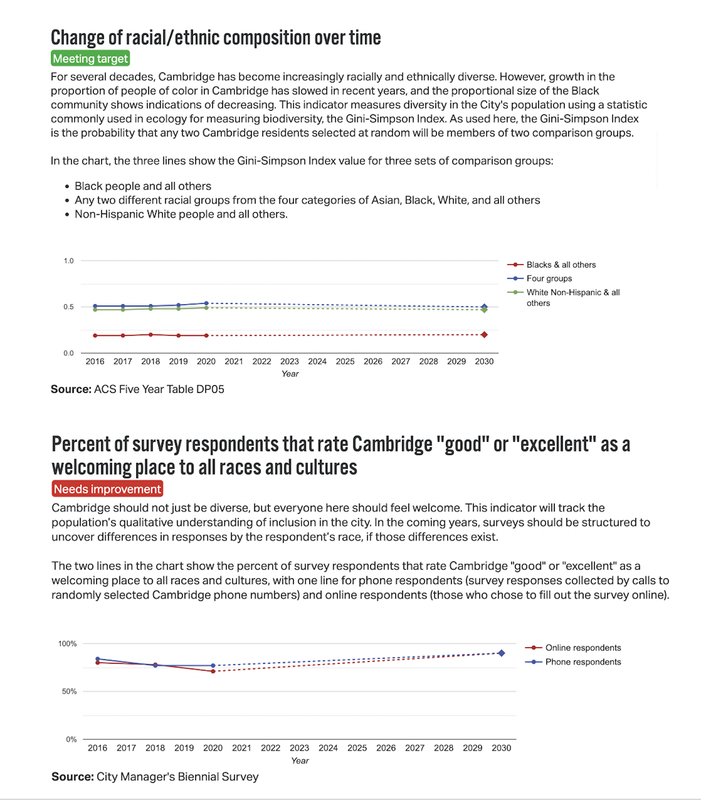 All told, this is a very mixed Community Well Being report. There are some serious questions about how the data on race and ethnicity were used ? to come up with these conclusions. _____________________________________________________________________________________________
Cambridge may be one of the top ten richest cities in the country, but we are not using our resources well. There are serious problems in the economic sector. Small businesses, particularly local businesses are the mainstay of any community - often paying the highest salaries, contributing more to the community, and being more responsive to events on the ground. Before COVID, our numbers of small retail, food service, and accommodation (inns, B&Bs etc.) businesses were down, with COVID they are likely to be even worse. The city has tried to help some during the critical COVID period, but we need to be far more proactive if we are going to bring any real change. On the plus side, more minority-and women-owned businesses are participating in city grants and other programs. However, while the numbers for Hispanic-owned businesses are up slightly, those of Blacks are down. For those with disabilities the numbers fluctuate, but are largely flatlined. 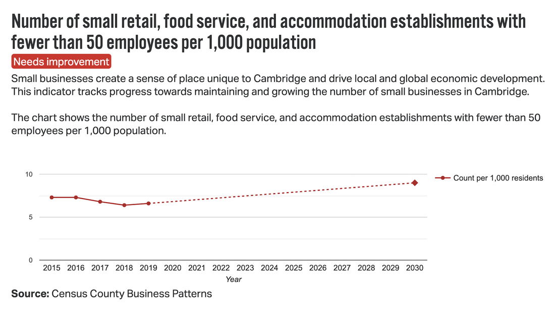 On median income by race and ethnicity Blacks and Hispanics have roughly remained the same; were we to add to this graph both Asians and Whites the results would be even more telling. On educational attainment the statistics are terrible, especially for a city that places so much emphasis on education and where we dedicate so much funding for it. The data show Blacks to be sliding down hill while Hispanics are increasing in achievement scores. Lower income more generally has flat lined. If we add Asians and Whites to this data set the results would look even worse. 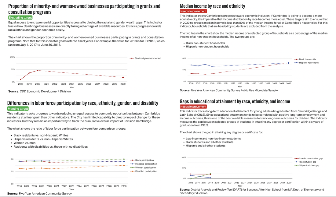 To get a far better sense of what is happening in Cambridge in terms of income differentials including school outcomes one needs to look at the Cambridge Community Foundation We need to use our resources better. We are wealthy. Cambridge has experienced the greatest percentage increase in median household income since 2010 out of all U.S. cities with more than 100,000 population. The Cambridge median household income has grown by 59% according to an April 2021 Forbes report, likely skewed by recent bio/tech and info/tech jobs. We must find the means and will to address equity even with this change. _________________________________________________________________________________
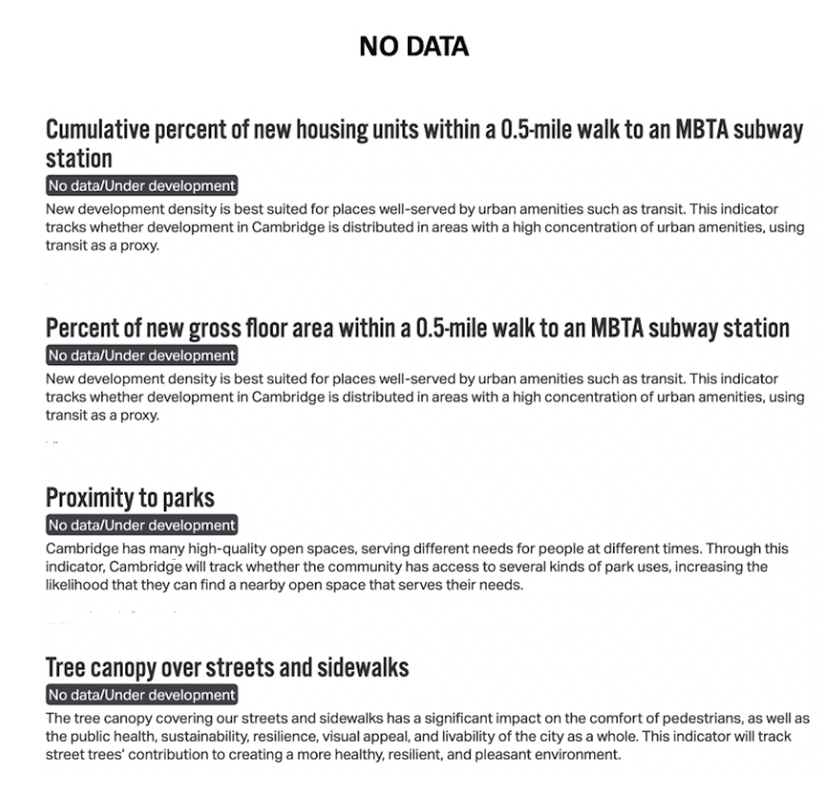
Much of CDD's focus in the last couple of years has been on housing, consistent with the widespread concern that housing costs are going up in the City as they are in many other places in the area, the country, and internationally. How is Cambridge handling this both important and deeply fraught issue? Not well. There is too much data missing in this interim report that the City should be providing. For example: what share of new housing produced in Cambridge is affordable; how many new affordable housing units have been produced; what is the annual investment in affordable housing initiatives from City sources. CDD clearly knows what these data are (many of them have been widely published) but have chosen not to do so here.
The number of total housing units has increased slightly. This is a good thing considering how dense a city we already are. Simply adding more market rate housing to an already over-heated housing market will not help us get to where we need to be. The city should be using its own properties for housing and should buy more for this purpose – particularly along major corridors. Ongoing gentrification appears to be a factor, yet to date no actions have been put forward by the City or City Council on how to counter this. Among the data that CDD has chosen to share with us is the change in race and ethnic composition of the city. Here we see too that CDD has placed Asians with Blacks rather than showing them separately. The comparative decrease in African diaspora residents is important to know, particularly since it is delineated as a significant issue for schools and the economy. We can also see here how few residents have children under 18, likely a result of job increases for younger residents and the growing number of our senior population. Wealthier individuals and developers continue to buy properties here; too often converting rental apartments into expensive condos or large single-family homes. Despite all the effort put into housing, the changes that the report has chosen to show, are not going in a positive direction except for the total number of housing units. 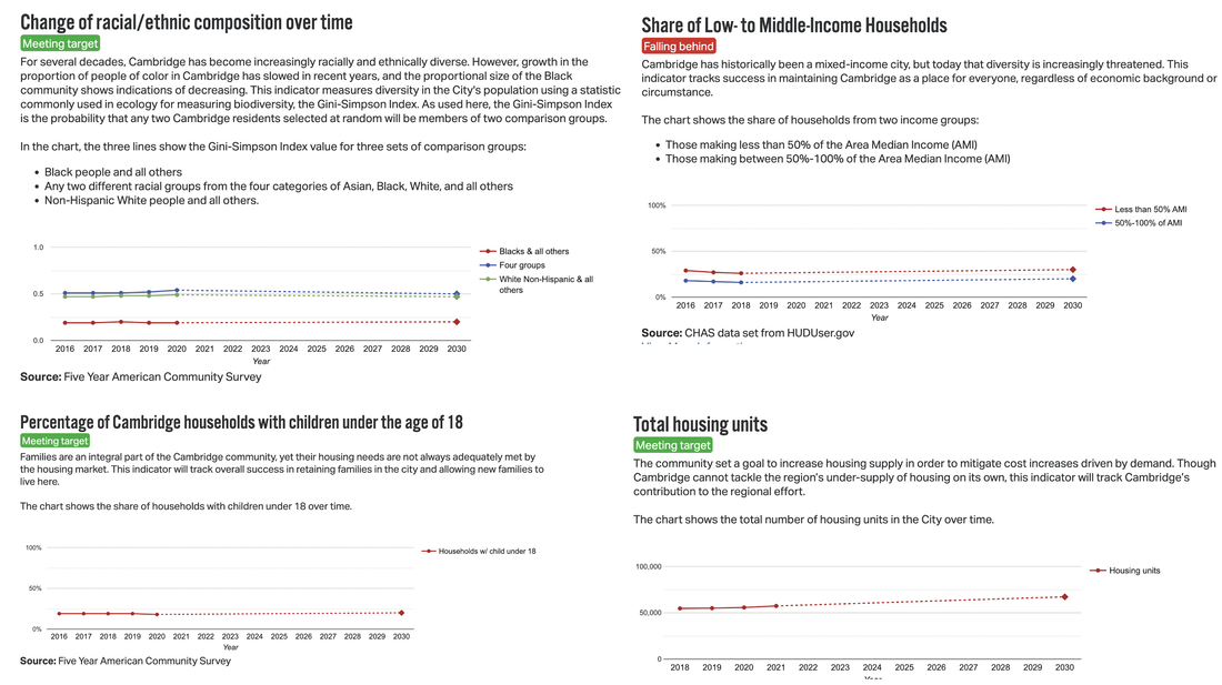 Despite all the effort put into housing, the changes that the report has chosen to show, are not going in a positive direction except for the total number of housing units. _________________________________________________________________________________
Transportation is a critical issue for Cambridge which is not only already very dense city but also has considerable cut-through traffic going to other places and more and more commercial development (adding tens of thousands of employees). Let's start with the good news.
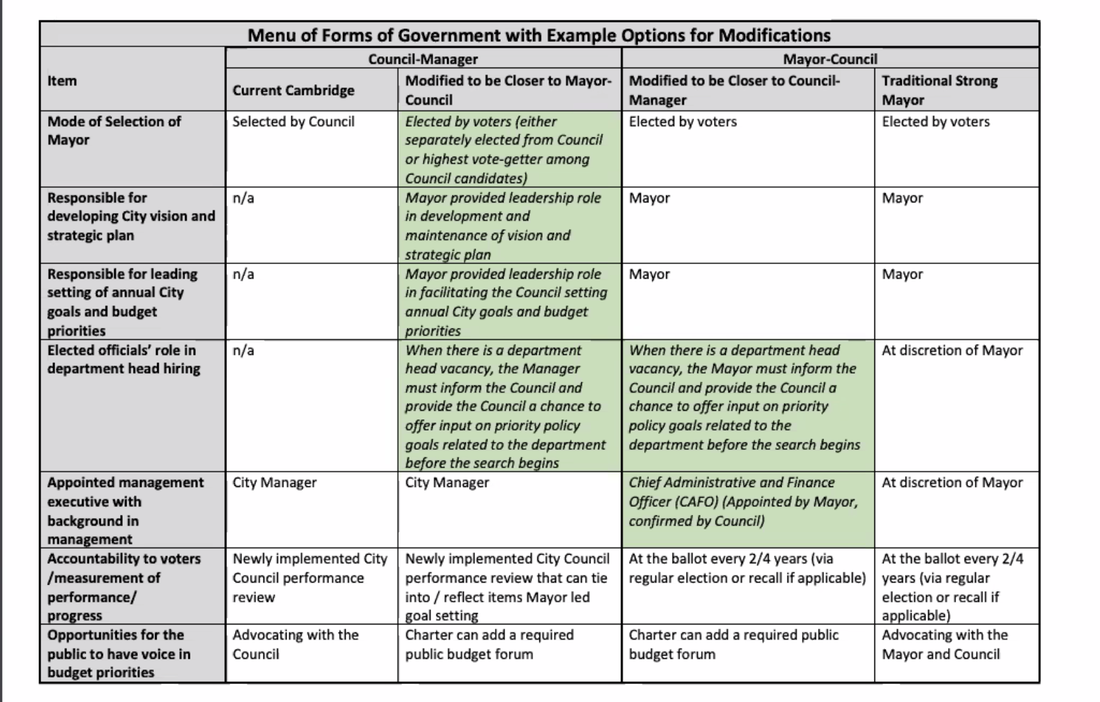
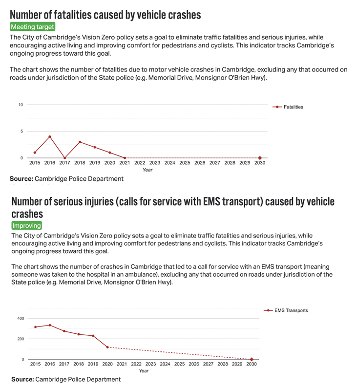 The rest of the mobility report is disappointing. We see key categories with no data even though we know such data exist. Why? CDD’s missing data include: available mobility options; the number of residents that live within 0.5 walking distance miles of an MBTA subway station; and the number of residents that live within 0.25 miles walking distance of an MBTA high frequency bus line. Sadly, the vital goal of getting more Cambridge residents out of their cars and traveling by public transit, by foot, by bike or other means shows flatlining both for those who live in Cambridge and for those who do not live here, but work in our city. One key problem is a lack of viable public transportation in key parts of the city. Another is So, in the end, there are major pluses (steep drop in accident seriousness and numbers) and serious minuses in this section. 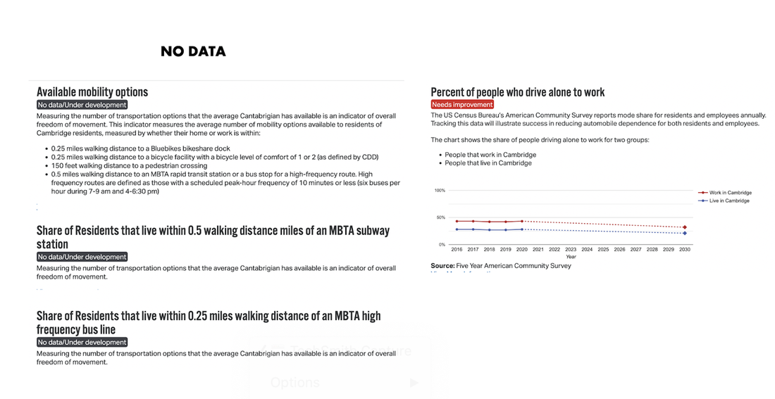 In sum, there are decided pluses (steep drop in accident seriousness and numbers) and minuses (key goals have flatlined or data is not included in this section. ___________________________________________________________________________________
The good news first: Residents are happy with the overall appearance of the city. In part we can thank the Cambridge Historical Commission and Neighborhood Conservation Districts for that. We also must thank our terrific Sanitation staff, as well as the BID in Central Square and the local Business Associations (in Harvard Square and East Cambridge) who undertake part of this work themselves. Here’s the bad news: Important Envision goals are left out of CDD's assessment for this section, including providing plans and design criteria for different city areas and various kinds of development that would be allowed or encourage. What has happened instead is developers putting forward a plan and then assuming that citizens and the Planning Board or BZA to tweak around the edges. We had hoped to get a new city plan, but CDD chose instead to give us Envision (with goals that are often contradictory). The City also has acquired little if any new land for critically needed new green spaces in the denser parts of the city to address both health and environmental inequities and justice. On private land, where green spaces and trees also matter for neighborhood vitality, CDD has been pushing for more infill market rate housing which will increase heat island impacts in much of the city. Why do we see the ongoing lack of City Planning? Why are only certain items in this section of Envision discussed in the report, leaving out other Urban Form goals, such as the need to preserve historic buildings, or to add greater height/density on some of the corridors for housing. 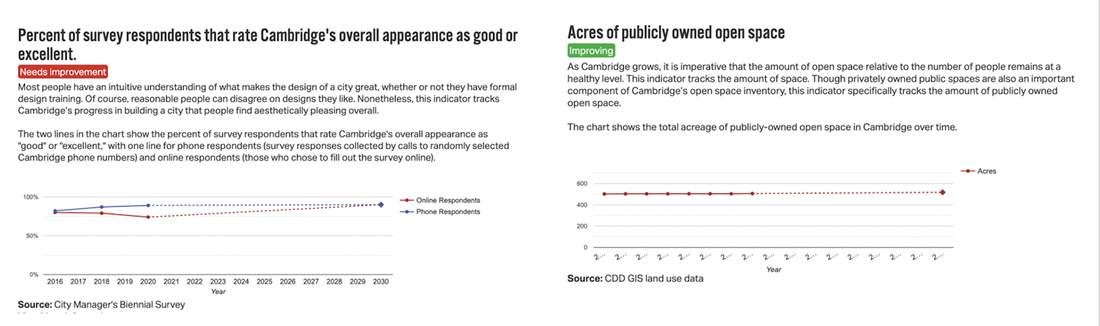 There is further bad news in the many sections with “Missing Data,” including information on new units near MBTA subway stations. The city should have acquired more properties specifically to meet these goals; the recent Lesley University/Porter Square sale is a case in point. We are missing data on residential proximity to parks even though we know this data is available. And why have no new areas for green space in our city's denser areas been acquired? Finally we are missing data for reversing the declining tree canopy over streets and sidewalks. Why? This is critical to making residences in denser parts of the city cooler, and for enhancing shopping in our Squares.
In the end, Envision’s Urban Form Goals are some of the most important for the city, and this is one of the largest sections of the Envision Report. Without strong planning we do not get to where we need to be for this generation of residents, much less for the next generation, and the one after that. _________________________________________________________________________________
In conclusion, the CDD report and the progress to date is replete with failures, missing data, problematic presentation of data, missed opportunities, and a lack of vision on how to bring about the kinds of changes that the residents of this notably wealthy, progressive, and caring city had hoped for and deserve. Residents had asked for a city plan but the city chose not to do one. Instead, we got a myriad of Envision "goals." But even in this they have failed to come through with what they promised and in far too many cases the city is backsliding. This was all happening before COVID. We need to do far better. And with new leadership, hopefully this will be possible. ___________________________________________________________________________________________ FINAL RESULTS
REPORT OVERVIEW
The report is deeply disappointing from the vantage of both progress and results. Based on what we are seeing here, it is unlikely we will reach the 2030 goals we set for ourselves in most areas. If the report were the work of any executive director of any professional organization, the individual and staff would certainly be held accountable for not meeting both annual and long-term goals (here our Envision Plan). To receive such bad scores on the Envision Goals Assessment at this juncture is deeply problematic.  THE SEARCH FOR A NEW CITY MANAGER IS NOW IN THE FINAL STAGE This decision will determine the City's current and ongoing direction for the near future. This is one of those key times that Cambridge residents need to be alert and participating in the process! The Selection Committee has chosen four Finalists for Cambridge City Manager (one of the original five has since dropped out). The screening committee members who selected these four finalists for City Manager is listed HERE UPDATE: a “Meet the Finalists” forum will be held on Tuesday, May 31st, 2022, from 6-9 p.m., in the Fitzgerald Auditorium at Cambridge Rindge and Latin School, 459 Broadway, where members of the public will have an opportunity to hear from each finalist in person or on Channel 99 about their vision for the City and answer questions. Two of these four finalists could be considered to be "Inside" Candidates and two are "Outside" Candidates. Read all four bios and questionnaire answers HERE. (We also have included them individually for each candidate below). Please submit questions for the four finalists to randi@randifrank.com by Thursday May 26 at 12 noon for the May 31st public forum with the finalists. . All questions should be applicable to all four applicants. The City Council also will conduct public interviews with the finalists on Wednesday, June 1st, beginning at 6:00 p.m. in the Sullivan Chamber, 2nd floor of Cambridge City Hall, which the public can view in person, on 22-CityView (the municipal cable channel), and live online via Zoom. Please contact each City Councillor with your preferences & rationales (see below for contact information and ideas) WHO ARE THE FINALISTS? CCC has chosen to list the OUTSIDE candidates first because the aim in not renewing the former City Manager’s contract for many, including many City Councillors who voted to replace him as Manager, was to find someone from outside the Cambridge system to provide new insights and to help create a city that works far better than it has in recent years. THE TWO OUTSIDE CANDIDATES ARE: YI-AN HUANG. He was Boston Medical Center’s Chief Transformation Officer during the critical COVID period (2019-21) and is now BMC’s Executive Director of Clinical Operations (2021-present). He comes with considerable management experience, addressing issues of transformation in a difficult change period. He holds an MBA from Harvard University. You can read his letter and questionnaire response HERE NORMAN KHUMALO. He has been the Town Manager of Hopkinton since 2009. He formerly was Westford’s Town manager, and a Town Planner for Walpole and Wellesley. Prior to that he was a Transportation Project Manager Lawrence, Ma. He is the only candidate with an MA degree in Public Management (Carlton College) the standard degree for Town and City Managers). He also holds an M.Sc degree in Regional and Urban Planning, and previously served as the Africa Regional Manager for Oxfam. You can read his letter and questionnaire response on the right. He also is a finalist for City Manager of Watertown. HERE is their May 12, 2022 Council interview with him. And here is the one-hour long interview with all the Watertown candidates: His engagement is from hour one to hour two in their VIDEO. He and the other finalists are discussed HERE. THE TWO INSIDE CANDIDATES ARE: IRAM FAROOQ. She is the current assistant City Manager who also heads up the Community Development Department which has been heavily involved in the issues of up zoning to add more residents and density and increasing commercial (especially lab) development citywide, including in residential areas. Many residents have not been happy with CDD decisions and efforts on a number of issues. Ms. Farooq has been a presence in many Planning Board and other meetings. She holds a degree in Landscape Architecture from Harvard’s GSD program. You can read her letter and questionnaire response HERE CHERYL WATSON FISHER. She is a founding partner in the Cambridge law firm of Galluccio and Watson, one of the city’s most well-known firms for city Real Estate and Development interests. She remains the contact person for Galluccio and Watson and is also the current City Solicitor for Chelsea Ma. (2003 to present). Prior to that she served as Assistant City Solicitor for Cambridge from 1999-2003. She appears to be continuing her Cambridge legal practice outside of her Chelsea Solicitor work, but the city bio does not indicate the location or fields of her ongoing private legal case work. She holds a law degree from Boston College. You can read her letter and questionnaire response HERE WHO DO YOU WANT TO SEE IN THIS POSITION? An INSIDE Cambridge candidate who in many ways is part of the system we have today, or an OUTSIDE Candidate. Feel free to identify specific candidates you do support or don’t support. At this point one should not focus on city-specific political issues because the criteria for selection has already been set, and all four finalists are said to be equally viable from that stand point. However:
This likely will be the MOST significant decision of the next few Council terms. For some of us this decision is so important we may choose it as our #1 criteria in the next election After you have read and heard the candidates, please contact each Councillor individually with your insights: Insider or Outsider, Top choices. This decision should be one that one’s vote in the next City Council Election will likely in part be based on. Mayor Sumbul Siddiqui: ssiddiqui@cambridgema.gov Vice Mayor Alanna Mallon: amallon@cambridgema.gov Councillor Burhan Azeem: bazeem@cambridgema.gov Councillor Dennis Carlone: dcarlone@cambridgema.gov Councillor Marc McGovern: mmcgovern@cambridgema.gov Councillor Patricia Nolan: pnolan@cambridgema.gov Councillor Denise Simmons: dsimmons@cambridgema.gov Councillor Paul Toner: ptoner@cambridgema.gov Councillor Quinton Zondervan qzondervan@cambridgema.gov |